


The development and utilization of coal, metal and non-metal resources involve mining and processing in underground or open pits. These important energy sources play an important role in promoting power generation, steel manufacturing and other industrial applications. Drone technology has been widely used in coal mining and plays an important role in survey and inventory management in the mining industry.
Drone Survey and Inventory Management in Coal, Metal and Non-metal Mining Industries
Drones equipped with high-resolution cameras and LiDAR sensors can conduct aerial surveys of mining sites, providing detailed topographic maps and 3D models for better planning and analysis. It can be used to monitor coal stocks, providing accurate volume measurements and real-time data on stock levels.

Drones equipped with sensors can monitor environmental parameters such as air quality, water quality and vegetation health in and around mining areas. It can perform visual inspections of mining equipment, infrastructure and structures to identify potential problems and reduce the need for manual inspections in hazardous areas. In the event of an accident or emergency in a mining area, drones can be deployed for search and rescue missions.
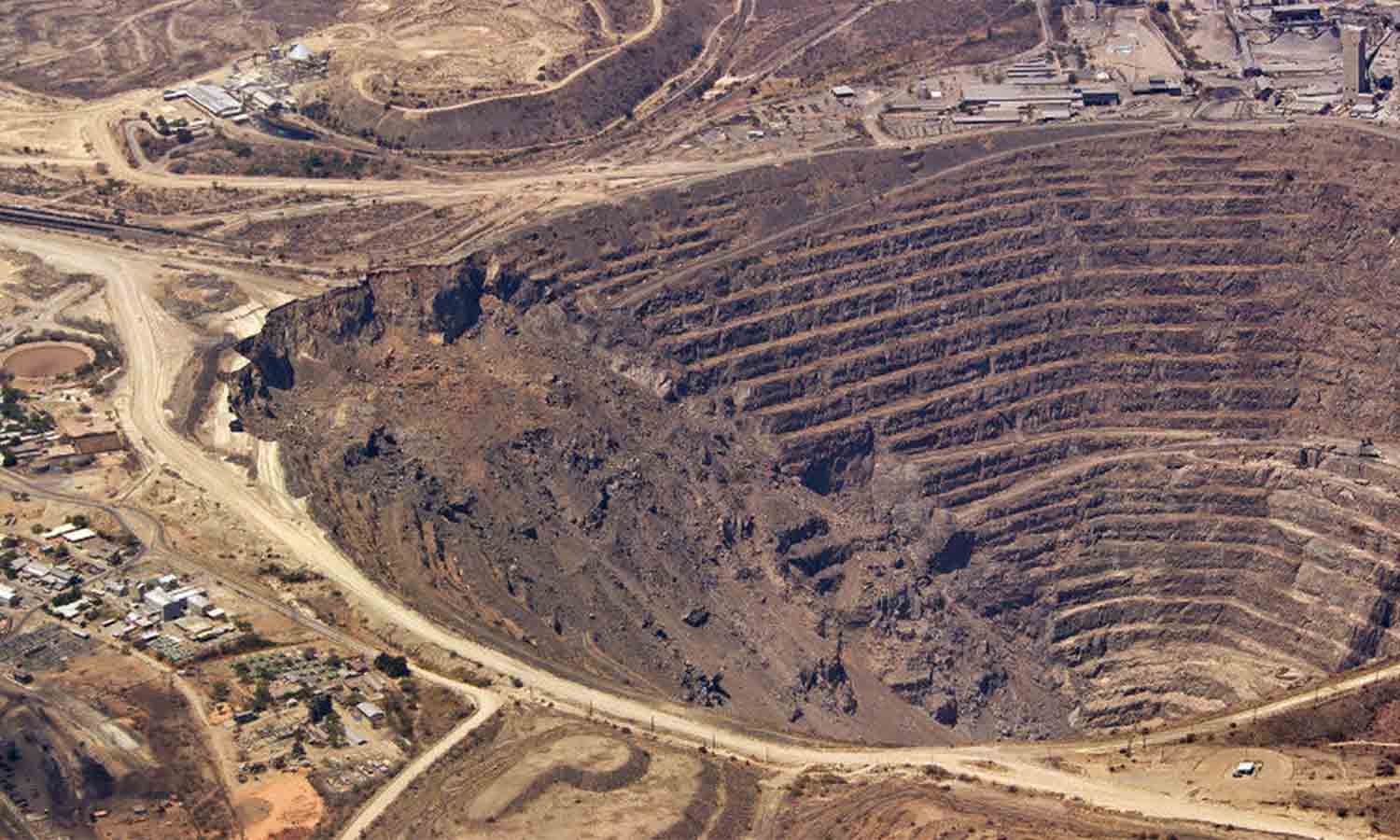
In the development of mine resources, underground mining, open-pit mining, coal processing, and coal transportation all have strict process requirements and complex operating procedures, including in the future mine repair work. Using the characteristics of drone automation and efficiency, 3D maps of these mines can be quickly drawn, allowing surveyors to continuously monitor the progress and safety of the mines.
View More: The Benefits and Role of RTK Drones For mining Industry
Application of drone surveying in the mining industry
1. Efficient topographic mapping and mapping
Traditional topographic mapping methods are time-consuming and laborious, while drones can complete the mapping tasks of large mining areas in a short time. Drones are equipped with high-resolution cameras that can take detailed images of mining areas and generate high-precision three-dimensional models. These data can not only help geologists better understand the topography of mining areas, but also provide important support for mine planning and management.
What data do drones provide for the mining industry?
Drone aerial photography surveying is to stitch together all the photos measured by mining drones. Surveyors can access different types of map views in post-processing software to obtain all the information they need.
Ortho-mosaic

Ortho-imagery output allows you to realistically view large areas and zoom in to the resolution level that a drone can capture. You can then use software tools to measure and analyze sub-areas when planning and managing your mine site.
Point Cloud

Point cloud output is a rendering of baseline data points for an area and is particularly useful for volumetrics because the points contain both horizontal and vertical spatial data. Other outputs of analytical value are based on point cloud data.
Digital Surface Model

Digital Surface Models provide a clear visual and analytical data for assessing the exposed ground in any area. With sharp color contrasts that represent changes in elevation of the exposed ground, the model is a great tool for examining topographic details when exploring potential mining areas and tracking changes in topography for remediation.
Digital Elevation Model

Digital Elevation Models are built on top of DSMs to capture detail of everything on the exposed ground, including vegetation, equipment, and finer details of the actual site. Everything is still coded to indicate differences in elevation. This output is ideal for easily tracking water and sediment flows.
Contour Maps

Contour map outputs provide a detailed view of the terrain of an area based on slope changes. These outputs can be used in conjunction with orthophotos to provide a more analytical assessment of realistic terrain images, but they are also very powerful tools in their own right.
2. Accurate Resource Exploration and Assessment
Drones can carry a variety of sensors, such as optical cameras, infrared cameras, and LiDAR (Light Detection and Ranging) devices, to conduct detailed exploration of mining areas. These sensors can capture a variety of information on the surface and underground of the mining area, helping geologists discover the distribution and reserves of ore. In addition, drones can enter hard-to-reach areas for detailed exploration work, greatly improving the accuracy and efficiency of exploration.
- Optical Cameras: Suitable for high-resolution image acquisition, visual exploration, and inventory measurement.
- Infrared Thermal Imagers: Used for temperature monitoring, safety inspections, and environmental monitoring.
- Radar: Provides high-precision terrain mapping, vegetation penetration, and disaster monitoring.

3. Real-time monitoring and safety inspection
Drones can monitor the mining area in real time and find potential safety hazards, such as landslides and collapses. At the same time, drones can regularly inspect the equipment and facilities in the mining area, timely discover and deal with problems, and reduce safety risks. This not only improves the safety of the mining area, but also reduces the cost of manual inspections.
Application of drones in inventory management
1. Accurate inventory measurement
Traditional inventory measurement methods usually rely on manual or ground equipment, which is time-consuming and error-prone. Drones can quickly and accurately measure ore inventory, and calculate the volume and weight of the ore by taking images of ore piles and generating three-dimensional models. This method not only improves the accuracy of measurement, but also greatly shortens the measurement time.
2. Dynamic inventory monitoring
Drones can fly regularly to take pictures of the latest situation in the mining area, helping managers to track inventory changes in real time. By comparing the measurement data of different periods, it is possible to accurately understand the consumption and replenishment of inventory, adjust the production plan in time, and ensure the smooth progress of the production process.
3. Data recording and analysis
The data collected by drones can be stored in the cloud for easy access and analysis at any time. By analyzing these data, potential problems in inventory management can be discovered and improvement measures can be proposed. In addition, these data can also be used to generate detailed reports to support management decisions.
Advantages of UAV drones Survey and Inventory Management
1. Improve efficiency
Drones can quickly complete large-scale survey and inventory measurement tasks, greatly shortening working time and improving work efficiency. Compared with traditional methods, the efficiency advantage of drones is particularly obvious.
2. Reduce costs
Although the initial investment in drones and their supporting equipment is high, in the long run, drones can significantly reduce manpower and material costs. Especially in dangerous areas, drones can replace manual tasks, reduce the risk of safety accidents, and further reduce costs.
3. Improve safety
Drones can conduct surveys and inspections in dangerous areas, reducing the time workers are exposed to dangerous environments and improving the overall safety of the mining area. In addition, through real-time monitoring and inspections, drones can promptly discover and deal with safety hazards and prevent them before they happen.
4. Accurate data
Drones are equipped with high-precision sensors that can collect accurate terrain and inventory data to ensure the accuracy of surveys and measurements. This data is not only important for daily management, but also provides a reliable basis for future planning and decision-making.
Aircraft surveying and drone surveying


Drone technology was first used by the military, and later, civil helicopters and manned aircraft began to serve some industries. Now, the potential of drones or unmanned aerial vehicles has a significant impact and change on various industries.
In the mining industry, the most important piece of data is geospatial data, which determines the final maps and models presented in decision-making reports. Data collection and geospatial analysis technology have made great progress in the past decade. Now, the process from collecting data from drones to turning it into useful information has been shortened by at least 50%, allowing managers and mine planners to make timely analysis and recommendations.
Mining drones are cheaper and more efficient than helicopters and manned aircraft in the mining industry. Using mining drones suitable for mining applications can save a lot of time and money, and more importantly, it is more accurate than using aircraft for surveying and faster.
View More: Top Drones for Mapping and Surveying 2024
Conclusion
The application of drone technology in the mining industry, especially in surveying and inventory management, has shown great potential and advantages. By improving work efficiency, reducing costs, improving safety and data accuracy, drones have brought unprecedented changes to the mining industry. With the continuous advancement of technology and the deepening of application, drones will surely play a more important role in the mining industry.


