


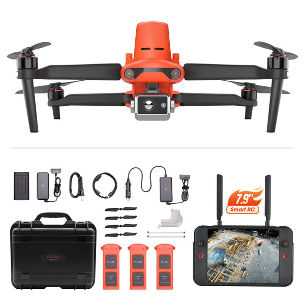
Autel Robotics EVO II Dual 640T RTK V2 Thermal Drone Rugged Bundle
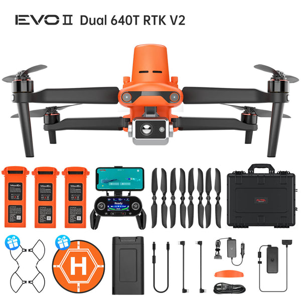
Autel Robotics EVO II Dual 640T RTK V2 Thermal Drone Rugged Bundle
- Free pair of propeller guards and Landing Pad
- No Geofencing
- 640*512 Thermal Imaging Resolution
- RTK module with centimeter-level accuracy
- 10 Thermal Color Palettes
- 8K Video/48MP Picture
- 360° Obstacle Avoidance
- Dynamic Track 2.0
- 38 Mins Flight Time
- 5.5 Miles Video Transmission Range
Fast Delivered by Wed, Apr 02 - Fri, Apr 04 Free Ship from USA
Fast, Free Shipping & No Extra Tax
30-Day Return or Replacement
12-Month Free Warranty
Lifetime Customer Support

- Overview
- Applications
- SPECS
- In the box
- Video
-
EVO II Dual 640T RTK
Autel EVO 2 Dual 640T RTK Thermal Imaging UAV is a professional and powerful commercial UAV. It integrates RTK module on EVO II 640T, which has unparalleled accuracy and centimeter-level positioning accuracy. The EVO II 640T has a 640x512 thermal resolution thermal camera and an 8k sensor camera, which can help you capture high-definition detailed images for optimal insight. This drone will be well-suited for applications such as geographic surveying and mapping.

Dual-sensor camera - 8K and infrared camera
Dual-sensor camera: Includes the 8K camera plus an infrared imaging camera. It can operate in visible, infrared, and dual-image modes. In addition, this camera takes infrared images at a resolution of either 640 x 512 (640) or 320 x 256 (320), and records 720p video at 30 fps in dual-image mode. Additionally, 8k and infrared imaging cameras capable of simultaneous recording.

More Applications for 640T Thermal drones
-
Thermal Drones In Wildlife Management
More than 6 million feral hogs roam the United States. From Hawaii to Florida, these invasive cousins of domestic swine have increased their range from 17 states in the 1980s to more than 35 states today. Able to breed year-round with average litters of five-eight piglets, feral hog populations can double in size within four months. Weighing between 75 and 500 pounds, feral hogs’ aggressive behavior is very destructive to agriculture, natural ecosystems, people, pets and livestock.
-
Thermal imaging helps spot predators that could injure or kill farm animals. This will ensure peace of mind for farm owners. This footage show just how hard Wild Boar are to identify with the naked eye but with the help of the thermal drone they are easy to locate and count.
-

Crops -

Pasture
-

Livestock -

Horticulture
-
-
Thermal imaging helps spot predators that could injure or kill farm animals. This will ensure peace of mind for farm owners. This footage show just how hard Wild Boar are to identify with the naked eye but with the help of the thermal drone they are easy to locate and count.
-
Crops -
Pasture
-
Livestock -
Horticulture
-
-
Thermal Drones in Hunting
Welcome to the drone world! While I am vegetarian, I can endorse your efforts for wanting to use a drone for hog hunting!
Using drones to hunt wild hogs is an excellent use case. Add a thermal camera, and they are easier to spot. Using drones to hunt hogs has been a common practice for many years, but it used to be extremely expensive; Hunters in the past have used $15,000+ rigs to make it happen.
Now drones with thermal cameras are cheaper than ever before — and extremely easy to fly.


-
Thermal Drones In Residential Roof Inspection
On shingle, tile or slate roof structures, you can document the exterior condition of the roof using UAV based high resolution visible imaging where we can easily observe hail damage, wind damage, openings in the roof, cracked tiles and much much more. When it gets wet, it creates a hotter temperature on the surface of the membrane that can be easily detected with infrared imaging.
-

Low Sloped | Flat Roof Scans You can identify moisture in commercial roofs with using EVO II Dual 640T Thermal Drone, confirm moisture with further physical testing and process a detailed report that calculates how much of the roof contains moisture. -

Shingle | Tile | Slate Roof Surveys Using drones with high resolution cameras, you can capture detailed images observing hail damage, wind damage, broken or missing shingles or tiles and more, processing detailed reports based on Thermal Drone 640T.
-
Low Sloped | Flat Roof Scans You can identify moisture in commercial roofs with using EVO II Dual 640T Thermal Drone, confirm moisture with further physical testing and process a detailed report that calculates how much of the roof contains moisture. -
Shingle | Tile | Slate Roof Surveys Using drones with high resolution cameras, you can capture detailed images observing hail damage, wind damage, broken or missing shingles or tiles and more, processing detailed reports based on Thermal Drone 640T.
-
-
Thermal Drones In Industrial Inspection
The EVO II 640T RTK uses an 8K Visual Spectrum Sensor and 640 Radiometric Thermal Sensor, giving inspectors the ability to perform multiple roof inspections in half the time it takes by conventional methods. Our drone kits will not only allow you to visually inspect the entire building , but also use thermal technology to check for hot spots. This enables you to safely and quickly check the status of the structure. As well as to help you identify defects, leakage, and corrosion issues, without having to spend on additional personnel and equipment.
-
Thermal Drones in Agriculture
The benefits of drones in agriculture have been well documented, but beyond monitoring crop and plant health, drones can also keep track of livestock with thermal cameras. In flight, a drone with thermal imaging capabilities is a powerful tool for monitoring many different types of wildlife. Thermal cameras can detect the heat signature from an animal at a distance, providing drone pilots with data they otherwise wouldn't be able to gather.
-
Thermal Drones In Wildlife Management
More than 6 million feral hogs roam the United States. From Hawaii to Florida, these invasive cousins of domestic swine have increased their range from 17 states in the 1980s to more than 35 states today. Able to breed year-round with average litters of five-eight piglets, feral hog populations can double in size within four months. Weighing between 75 and 500 pounds, feral hogs’ aggressive behavior is very destructive to agriculture, natural ecosystems, people, pets and livestock.
-
Thermal imaging helps spot predators that could injure or kill farm animals. This will ensure peace of mind for farm owners. This footage show just how hard Wild Boar are to identify with the naked eye but with the help of the thermal drone they are easy to locate and count.
-
Crops -
Pasture
-
Livestock -
Horticulture
-
-
Thermal Drones in Hunting
Welcome to the drone world! While I am vegetarian, I can endorse your efforts for wanting to use a drone for hog hunting!
Using drones to hunt wild hogs is an excellent use case. Add a thermal camera, and they are easier to spot. Using drones to hunt hogs has been a common practice for many years, but it used to be extremely expensive; Hunters in the past have used $15,000+ rigs to make it happen.
Now drones with thermal cameras are cheaper than ever before — and extremely easy to fly.
-
Thermal Drones In Residential Roof Inspection
On shingle, tile or slate roof structures, you can document the exterior condition of the roof using UAV based high resolution visible imaging where we can easily observe hail damage, wind damage, openings in the roof, cracked tiles and much much more. When it gets wet, it creates a hotter temperature on the surface of the membrane that can be easily detected with infrared imaging.
-
Low Sloped | Flat Roof Scans You can identify moisture in commercial roofs with using EVO II Dual 640T Thermal Drone, confirm moisture with further physical testing and process a detailed report that calculates how much of the roof contains moisture. -
Shingle | Tile | Slate Roof Surveys Using drones with high resolution cameras, you can capture detailed images observing hail damage, wind damage, broken or missing shingles or tiles and more, processing detailed reports based on Thermal Drone 640T.
-
-
Thermal Drones In Industrial Inspection
The EVO II 640T uses an 8K Visual Spectrum Sensor and 640 Radiometric Thermal Sensor, giving inspectors the ability to perform multiple roof inspections in half the time it takes by conventional methods. Our drone kits will not only allow you to visually inspect the entire building , but also use thermal technology to check for hot spots. This enables you to safely and quickly check the status of the structure. As well as to help you identify defects, leakage, and corrosion issues, without having to spend on additional personnel and equipment.
-
Thermal Drones in Agriculture
The benefits of drones in agriculture have been well documented, but beyond monitoring crop and plant health, drones can also keep track of livestock with thermal cameras. In flight, a drone with thermal imaging capabilities is a powerful tool for monitoring many different types of wildlife. Thermal cameras can detect the heat signature from an animal at a distance, providing drone pilots with data they otherwise wouldn't be able to gather.
Thermal Imaging Function
-
Picture-in-Picture Mode
Visual and thermal imagery are combined to help users quickly interpret data and critical decision making. From top to bottom are "Picture in Picture Mode", "infraed More", and "visible Light Mode"

-
Spot Temperature Measurement
Tap the screen, and the temperature of the selected object will be displayed in real time.
-
Regional Temperature Measurement
Get a dynamic view of the average temperature, maximum temperature, and minimum temperature displayed in a selected area.
The temperature measurement frame can be dragged to any position on the screen.

-
Temperature Warning
Monitors the screen temperature in real time. The system prompts the user when the temperature reaches a set thresholds
Note: The temperature alarm takes effects only in Regional temperature measurement mode
-
Image Enhancement
Supports real-time adjustment of image brightness, contrast, and image details. The system will highlight any objects within the temperature target.
-
10 Thermal Color Palettes
White Hot | Cold and Hot | Rainbow | Enhanced Rainbow | Iron bow | Lava | Arctic | Searing | Gradation | Heat Detection

-
4x Lossless Zoom

-
Human Search
Powerful Infrared Thermal Analysis Tool(IRPC)
This free temperature measurement analysis tool is developed for the 640T, and enables users to quickly import images, edit and analyze temperature measurement, and to generate detailed reports for sharing and coolaboration.(Select the "Word" icon Export report. Generate analysis report)
All three camera modules support a variety of shooting modes, including: Single-shot; Burst shooting; Auto exposure bracketing (AEB); Time-lapse; High-dynamic-range (HDR) imaging; NIGHTBEAT (high signal-to-noise ratio)
Connect Autel Live Deck to display live on any device
A high-definition live feed from the EVO 2 drone camera can be displayed on your remote control’s screen or connect with Autel Live Deck to displayed on any device including computer, tv, phone, etc. Of course, Images and videos can be stored in the aircraft’s onboard memory or on a micro SD card.
Adjust field-of-view to any angle from 0° to 90° while flying
EVO II Dual 640T RTK Drone contains a high-precision 3-axis gimbal that keeps the camera steady while the aircraft is flying, ensuring image stability and clarity. Also, You can use the remote control's gimbal pitch dial to adjust the pitch axis to any angle from 0° to 90° at any time.
All Cameras interchangeable
Autel EVO II Series Dones is one aircraft with three camera options. All cameras for Evo II can be purchased separately and are interchangeable!

Autel EVO II Dual 640T RTK Module
Centimeter-Level Positioning System
The EVO II RTK series integrates an entirely new RTK module, which provides real-time centimeter-level positioning data and supports Post-Processing Kinematic (PPK). The EVO II 640T RTK aircraft can record the original satellite observation data, camera exposure parameters and various other data. The positioning system supports A-RTK base station and RTK network, which helps to achieve accurate and stable data acquisition in complex operation environments.

Mission Execution With Advanced Intelligence
EVO II 640T RTK aircraft offer users a full range of intelligent features and solutions to suit a variety of mission needs. Using advanced flight control and the latest AI technology, the aircraft can significantly improve mission work flows and help reduce operating costs.
Creating Mission, Waypoint Flying, 720° Omnidirectional sensing & Obstacle avoidance, Photo Replication, No Need Ground Control Points, High Precision RTK/ PPK Positioning, Support A-RTK High Precision GNSS Base Station.

No Need for Ground Control Points
The EVO II RTK Series leverages a high precision RTK module, supports PPK and time synchronization, and is not limited by communication links or network coverage.

-
RTK / PPK
The Evo II RTK Series supports third party base stations with NTRIP capability

-
RTK High-precision GNSS Base Station
The EVO II RTK Series supports RTK high-precision GNSS base station to obtain real-time differential data, which makes it possible to obtain the accurate coordinates of the designated target point.

-
RTK / PPK
The Evo II RTK Series supports third party base stations with NTRIP capability
-
RTK High-precision GNSS Base Station
The EVO II RTK Series supports RTK high-precision GNSS base station to obtain real-time differential data, which makes it possible to obtain the accurate coordinates of the designated target point.
EVO II - AI Enhanced Dynamic Track
EVO II Dual 640T RTK smart tracking uses deep learning algorithms to automatically track the selected subject while avoiding obstacles during flight. The function can track the subject in three modes: behind, side-by-side, or fixed position.
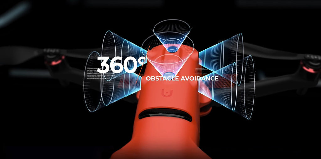
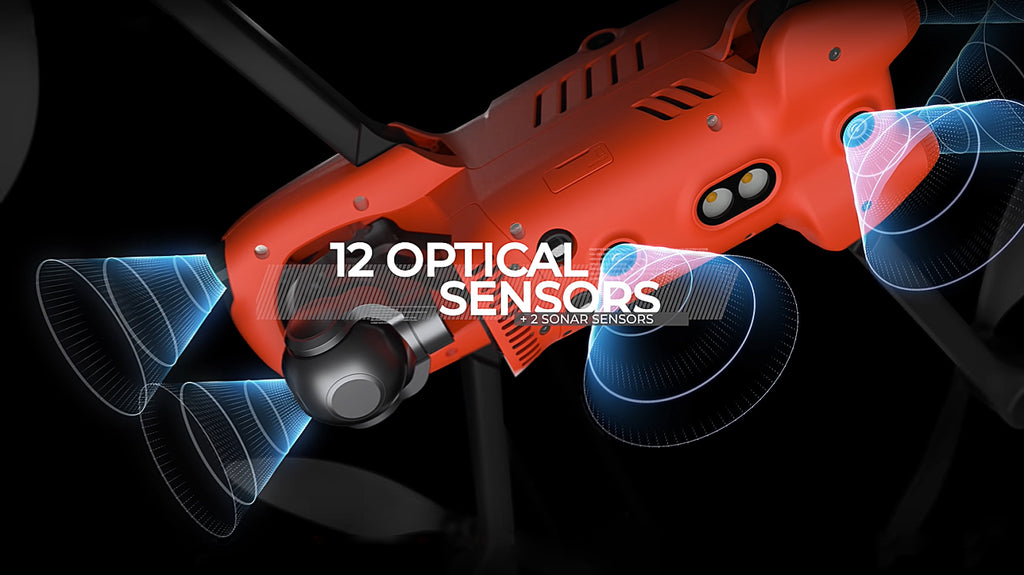
360° Obstacle Avoidance
EVO 2 Dual’s front, rear, left, right, top, and bottom binocular vision sensing systems use image data to calculate the distance between the aircraft and potential obstacles. Begin detecting potential hazards at up to 30m away and let EVO II accurately control the speed of the drone to avoid a collision.
Viewpoint
Viewpoint allows the user to send the aircraft to a selected destination by touching a point on the screen. Featured with the same waypoints function as EVO to program autonomous flight routes. EVO II Dual 640T RTK can even save multiple waypoint missions making it easy for surveying.
Auto go home & Accurate Landing
EVO 2 Dual 640T RTK will return home automatically when Low Aircraft Battery Level and Communication Lost. Additionally, EVO 2’s bottom binocular vision camera to create a density depth map. Then, it calculates the depth map's flatness and angles to ensure an accurate and safe landing.
Super Battery Life & 9KM Extended Range
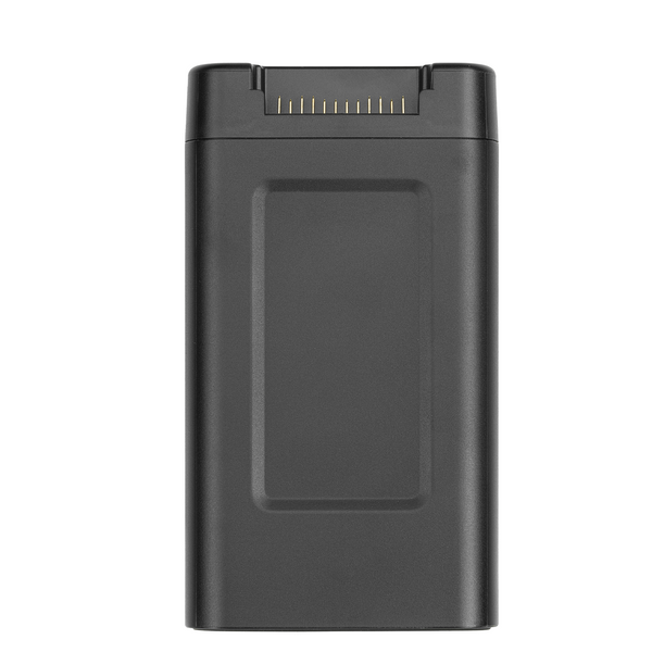
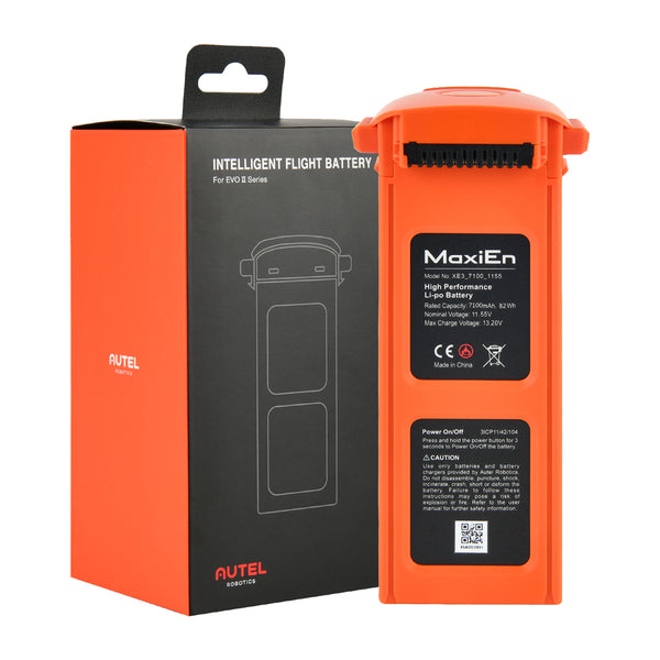
Autel EVO 2 Dual 640T RTK comes standard with a 7100mAh rechargeable battery. Providing up to 38min of flight time in forward motion to up to 9km away and 35min at a hover. And top speed up to 45MPH, additionally There is no geofencing or cellular service restrictions on any of EVO II Dual.


Need More EVO II 640T RTK details and more discounts,Just Contact Us
 E-Mail Or
  WhatsApp Online Chat
 -


Best Recommend

Deliver to USA
Fast Arrivel by: April 1 - April 3
**** on hawgs!!
It has been a great asset for locating feral pigs. And just plain fun to fly and look around at night.
Good! Support
This is one of the most expensive devices I have purchased this year, and the EVO II 640t did not disappoint! Well worth the wait! The 640t RTK can be used not only for geographic mapping but also at night. The 640*512 night infrared thermal imaging mode makes me amazed at this drone. It doesn't stop there, and I'll experiment with more.
Amazing rtk drone!
You'll find everything you need to start a fun hobby. In addition to the lens filter, blade guards, gimble protector, and a short cord, I also purchased a lens filter for my iPad. Everything else you need was in the kit I bought.
The best RTK drones
This drone brings me a whole new experience, great performance, nice shape, foldable wings, I really like it. The EVO II Dual 640t is a thermal camera drone with an RTK module, you can't imagine how awesome it is!


