


The combination of drone technology and land surveying is an important development trend in the field of geographic information science in recent years. Unmanned Aerial Vehicles (UAVs) have brought new tools and methods to land surveying, changing the traditional surveying and mapping operation process. Drone solutions quickly collect accurate geotagged data, while photogrammetry software processes this data to provide standardized output.
Main advantages of land surveying
Cadastral survey
Quickly create realistic models with drawings and attachments using high-precision drone solutions to increase the efficiency of data collection.
Land cover and land use changes
2D orthomosaics were generated in real time so the team could immediately visualize land cover and identify any changes.
Topography
Use drones to quickly map and model large areas, generating data for accurate 2D and 3D models.
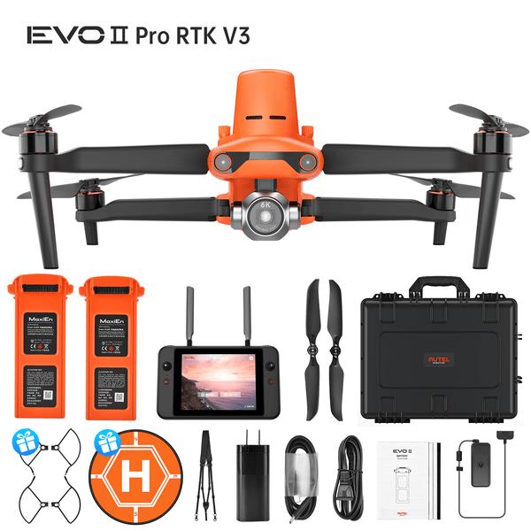
Autel Robotics EVO II Pro RTK V3
- Centimeter-Level Positioning
- Support PPK
- RTK Base Station
- NTRIP RTK Network
- Flight Profiles Save
- Rectangular or Polygon Missions
- 1" CMOS Sensor Gimbal Camera
- 360° Obstacle Avoidance
- 38 Minutes Flight Time
- 15km Video Transmission Range
Cadastral survey

Traditional challenges in cadastral surveying
On-site work requires extensive man-hours from many teams, extending project times and incurring higher costs.
It is difficult to visualize the property or parcel of land in question using only traditional survey results such as vector diagrams.
How drones improve the level of cadastral surveying
Generate 1:500 scale maps with centimeter-level accuracy without using GCP.
Increase data collection and processing efficiency by up to 10x, quickly achieve deliverables and shorten project lifecycles.
Get industry-standard output such as DOM, DSM, 3D reality models, and more.
Small teams can quickly cover large areas by operating multiple drones using a single remote control.
Land cover and land use

Traditional challenges in managing land cover and land use change
Satellite data is expensive, not available on demand, and has poor resolution and data accuracy.
Field work using total stations and handheld RTK devices is slow and inefficient. Collecting usable data in remote areas or where there are obstacles is difficult.
How drones can help manage land cover and land use change
Quickly visualize results using real-time 2D orthomosaics, or create accurate high-resolution maps in post-processing.
Dramatically reduce costs by using affordable drones and software solutions for automated data collection and processing.
Keep digital records that can be easily used for regular land cover comparisons so the team can dynamically monitor changes.
Topographic Surveys

Autel Robotics EVO II 640T RTK V3
- 7.9" Smart Controller V3
- 15KM Image Transmission
- SkyLink 2.0
- 50MP Picture/0.8" CMOS Sensor
- 640*512 Thermal Imaging Resolution
- 10 Thermal Color Palettes
- 360° Obstacle Avoidance
- Dynamic Track 2.1
- 38 Mins Flight Time

Traditional challenges in conducting topographic surveys
Requires extensive field work involving multiple teams and stakeholders. The project cost is high and the construction period is long.
Projects are often delayed due to inefficient data collection methods.
Profile data is not part of the standard deliverables, making data visualization difficult.
How Drones Help Topographic Surveying
Generate 1:500 scale maps with centimeter-level accuracy without using GCP.
Increase data collection and processing efficiency by up to 10x, quickly achieve deliverables and shorten project lifecycles.
Get industry-standard output such as DOM, DSM, 3D reality models, and more.
Small teams can quickly cover large areas by operating multiple drones using a single remote control.


