


Drone mapping is the use of unmanned aerial vehicles (drones) to collect geospatial data and generate high-precision maps and 3D models. So, can drone thermal images be used to generate geospatial maps? Here, we will take you through drone thermal mapping.
What is drone thermal mapping?
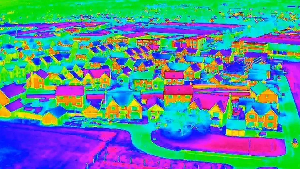
Drone thermal mapping is the use of drones equipped with thermal imaging cameras to map and analyze the heat distribution of the ground or buildings. By collecting infrared radiation information from the surface or target area, a thermal map (also known as a thermal image or thermal spectrum) is generated to show temperature differences and heat distribution.
Who uses drone thermal mapping?

Image from the Internet
Drone mapping has completely changed the way we capture and analyze data from the air. At the same time, when it comes to thermal imaging, drones equipped with thermal imagers have opened up new possibilities for mapping.
Thermal imaging mapping is essential for professional industrial applications such as precision agriculture, heat loss detection, and solar panel monitoring.
- Building inspection: Detect heat loss, air leaks, and poor insulation in buildings.
- Agriculture: Monitor crop health and identify temperature anomalies caused by lack of water or disease.
- Power Utilities: Detect overheated areas in power lines, substations, and other facilities to prevent failures.
- Environmental Monitoring: Monitor water temperatures, wildlife activity, or early detection of forest fires.
- Public Safety and Rescue: Search for survivors at disaster sites, detect heat sources in fire areas.
What is the key to thermal mapping?
One of the biggest challenges in the field of professional thermal imaging mapping in the global commercial drone industry is to retain radiation information throughout the image collection, processing, and mapping process. Therefore, drone performance and thermal imager resolution are critical.
Mapping and mapping thermal data using thermal imaging drones requires a high-resolution thermal imaging camera - at least 640 pixels x 512 pixels. The larger the pixels, the clearer the image. Autel thermal imaging drones all support 640*512 resolution, and the 640T series drones also support picture-in-picture mode, and the drone can export 1920*1080 picture files.

Object emissivity is the key to the accuracy of object temperature measurement by thermal imagers. Understand the emissivity of the measurement target and set the emissivity parameters of the thermal imager to obtain accurate results. In addition, when measuring temperature outdoors, atmospheric influence, solar radiation, ambient temperature and humidity, background reflection, and measurement distance will all interfere with the accuracy of temperature measurement.
To ensure the accuracy of thermal imaging drone mapping, you can also use drone RTK modules to control the accuracy of drones to the centimeter level, which is very effective for 2D/3D map creation and saves a lot of labor and time costs.
Can Autel drones perform thermal mapping?
To enable drones to perform thermal mapping, drone payloads require thermal imagers, high-resolution cameras, RTK modules, etc. Autel EVO II Dual 640T V3 and Autel EVO MAX 4T RTK Bundle can perform drone thermal mapping projects.
Autel EVO II Dual 640T V3 and Autel EVO MAX 4T RTK Bundle are equipped with 640*512@25fps resolution thermal imager cameras, supporting network RTK/PPK/RTK, and centimeter-level accuracy can be fully applied to create radiometric 2D or 3D maps.
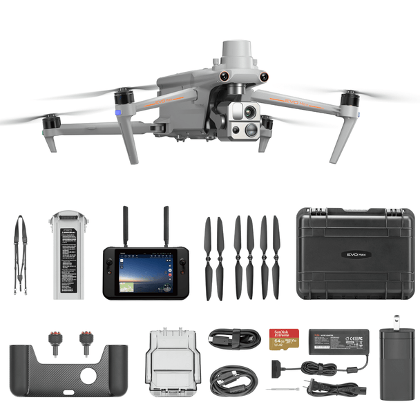
Autel Robotics EVO Max 4T With RTK Module
$9,299.00 USD
640*512 Thermal Camera | Multi-sensor Gimbal Camera| Centimeter-level Accuracy RTK Module Buy Now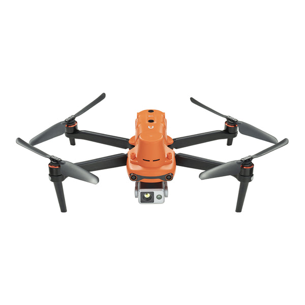
Autel Robotics EVO II Dual 640T RTK V3 Thermal Drone Rugged Bundle
$5799.00 USD
640*512 Thermal Camera | 8K 50MP Camera | Centimeter-level Accuracy RTK Module Buy NowUsing thermal imaging drones for mapping is a complex application, but due to its considerable return on investment, drone thermal mapping has become an indispensable technical tool in many industries.


