


Want to get detailed aerial orthophoto maps and actionable data for your project? Try drone photogrammetry! There are two ways to do drone aerial surveys, orthophotos and oblique photography. Here, we will fully explain drone aerial survey orthophotos!
What is drone aerial survey orthophotos?
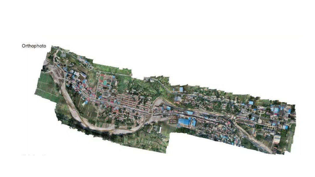
Orthophotos are two-dimensional images with real geographic coordinates generated by processing high-resolution image data taken by drones. You will also come into contact with orthomosaic image, orthoimage, orthomosaic image, or orthophotograph, they all mean the same thing!
Orthophotos eliminate the oblique effects of terrain and buildings, provide accurate and true surface views, and ensure that images can be correctly scaled to each other and are not widely distorted. Drone photogrammetry orthophotos are widely used in geographic information systems (GIS), urban planning, agricultural monitoring, environmental protection and other fields.

The process of generating drone aerial survey orthophotos
Flight planning:
Plan the flight path and shooting parameters of the drone according to the target area and mission requirements to ensure the coverage and overlap of the image.
Data Collection:
Use high-resolution cameras to take multi-angle, multi-overlap aerial photos to ensure full coverage of image data.
Image Processing:
Use professional software to stitch and orthorectify images to generate distortion-free 2D images.
The correction process includes geometric correction and radiometric correction to eliminate geometric deformation and uneven lighting in the image.
Geographic Reference:
Combining ground control points (GCP) and drone GPS data, orthophotos are given real geographic coordinates.
Output and Application:
Export the generated orthophotos to standard geographic information formats for use by GIS software and other application systems.
Why do we need orthophotos?
Orthophotos are not traditional drone aerial photos. Orthophotometry involves taking multiple images of a feature and correcting for perspective, camera tilt and lens distortion, which are ultimately used to create highly detailed, distortion-free maps. Orthophoto maps can also be converted into interactive 3D assets.
Proper use of orthophotos allows photos to be accurately scaled from one image to another, allowing reliable measurements to obtain true distances. This will greatly improve the precision and accuracy of drone surveys.
Let's understand orthophotos
Digital orthophotos are digitally differentially corrected and mosaicked aerial photographs, and cropped according to a certain range of images. It is an image that has both map geometric accuracy and image characteristics.
When shooting from a high altitude, the central projection rays are nearly parallel, and the orthophoto projection error caused by the height difference of local objects can be ignored, the image can be orthophotoed, and tilt angle distortion may also occur.
Orthorectification also removes perspective from each individual image to create consistency across the map while maintaining the same level of detail as the original image.
At the same time, pay attention to occlusion issues in drone photography. Occlusion is a problem that exists in close-range photogrammetry when shooting at any angle, and aerial photogrammetry cannot avoid this problem. At this time, drone oblique photography can be used to adjust more angles to generate better drone photogrammetry maps.
Advantages of orthophotos
Orthophotos have the advantages of rich information and strong intuitiveness, simple data structure, good interpretation and measurement performance, short production and update cycle, low cost and high efficiency.
- High precision: Using high-resolution cameras and precise flight control systems, drones can generate very detailed image data to meet the needs of refined mapping.
- High flexibility: Drones can fly in complex terrain and dangerous areas to obtain data in areas that are difficult to cover with traditional methods.
- Cost-effectiveness: Compared with traditional aerial photography and satellite remote sensing, drone aerial surveys have lower costs and higher flexibility.
- Quick response: Drones can complete data collection and processing in a short time, which is suitable for tasks that require rapid acquisition of geographic information.
Application areas of ortho-mosaic maps
As a digital mapping product, ortho-images have geometric accuracy, mathematical accuracy and image characteristics, with large information volume, rich content, intuitive and real, and are widely used in land acquisition and demolition, urban planning, land management, environmental analysis, green space surveys, cadastral surveys, river management, etc., and can also be superimposed with line drawings and text annotations to form image maps.
Overall
The rapid development of drone aerial survey ortho-image technology has provided efficient and reliable geographic information solutions for all walks of life, greatly improving work efficiency and scientific decision-making.
Whether you want to use ortho-images for land surveying or one of the other wide-ranging applications, Autel Robotics provides you with professional survey drones to complete drone photogrammetry ortho-images. Check out our best survey RTK drones to provide ortho-images and maps with detailed imaging and terrain accuracy for your engineering projects.


