


Drones with post-processed kinematics (PPK) and real-time kinematics (RTK) greatly simplify the workflow and help professionals in their surveying work. For pilots who are "mapping" with drones, what is PPK or RTK technology, how RTK drones work and what mapping drone is best for your surveying needs.
Precise Measurements, Starting With GPS Drones
The Global Positioning System (GPS) is used to track location and aid in navigation. Anyone with a standard GPS receiver can determine their location on Earth. Want 100% accuracy? Want to get the best gps module for drone? You must correct your GPS data. You need to correct GPS data in real time or apply corrections after GPS data is collected when viewing a drone survey. This brings us to GCP, PPK and RTK technologies.
GCP Is Used To Provide Precise Georeferencing
GCP, also known as ground control point, is the original way to achieve positioning accuracy when flying a drone, a GCP is just a location or object on the ground with accurate known coordinates (usually represented by a cross), stating its exact location and The distance it travels between the two places.
Drone GPS Correction Technology
The GPS correction technology built into drone processing does not require the same timely and expensive preparations as setting up GCP. Differential correction techniques are used to improve the quality of location data collected from GPS receivers. This is Differential GPS (DGPS).
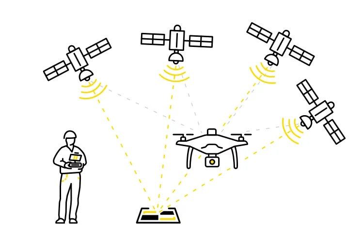
Drone buyers have two options for implementing a DGPS solution - PPK or RTK.

Development Of PPK Or RTK Technology
RTK is applying correction to location errors during the drone flight. PPK is applying correction after the flight.
Real-Time Kinematic (RTK) is a GPS correction technology that makes real-time corrections to location data as drones measure and capture field images.
Post-Processed Kinematics (PPK) is a GPS correction technique that corrects location data after it has been collected and uploaded. After the flight, the data can be uploaded to the cloud for processing or processed using dedicated software on the desktop.
The drone RTK processes recorded GPS information and geotagged images taken during flight. The ground station also sends raw GPS data to the drone. The software combines this information with the drone's own observations to accurately determine the position of the flying unit relative to the base. Data is provided via mobile data, Bluetooth or WiFi connection.
Using PPK technology, the drone will geotag coordinates to each image it collects. While this is happening, the base is also using precise triangulation calculations to record location information. After the flight, the two sets of GPS data are matched. The initial, somewhat inaccurate, onboard GPS data is then corrected to provide precise geotagging of the points being measured.
Which Is Better? RTK Or PPK

Faster, more real-time RTK drones can correct field data and geotags throughout the flight in real-time, and save time without the need for post-processing. At the same time, robust communication systems and consistent connectivity from ground and air equipment are essential.
PPK drone surveys require more time after flight to process the collected data and implement GPS corrections. Does not depend on signal strength or GPS communication between the drone and the base station. Has more flexibility to fly in more challenging environments.
The two techniques are very similar, but which technique is best for any given project depends largely on the nature of the task itself.
Regardless of which system is the "best" or "best fit" for the project being planned, it is clear that drones equipped with GPS correction systems are revolutionizing mapping and mapping.

Autel EVO II RTK series is guaranteed in terms of efficiency, quality of captured data and images, and safety, high-resolution camera sensor, strong flight performance, 10 color logs, support for PPK, GNSS base stations, and NTRIP function third-party base stations.
The best mapping quadcopters can return large amounts of accurate and precise position and measurement data and play a huge role in tasks that require mapping in a variety of industries.
View More: Drone Mapping: RTK VS PPK VS GCP


