


Drone photography is the first thing most drone users do when they get their hands on a drone. Drone aerial photography is so appealing, giving you a bird’s-eye view of the world from another perspective.
Because of this, drone surveying and mapping jobs are highly dependent on the drone’s high-resolution camera sensors, and drone photogrammetry brings a new power to the mapping industry!
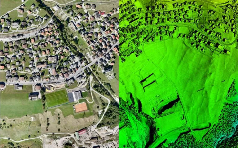
What is aerial photography?
Aerial photography is the technique of taking images of the earth's surface from aerial platforms (such as aircraft, drones, helicopters, etc.). These images can be vertical, oblique, or panoramic.

Purpose:
Mainly used to record surface features, create maps, monitor environmental changes, urban planning, military reconnaissance, etc.
Features:
- Image acquisition: Use high-resolution cameras to take large-scale surface images from high altitudes.
- Wide application: Can be used for mapping, urban planning, environmental monitoring, archaeology, military reconnaissance, etc.
- Image types: Including color images, black and white images, infrared images, etc.
- Technical requirements: Requires a stable flying platform and high-precision camera equipment.
Advantages:
- Rapidly cover large areas.
- Provide high-resolution surface images.
- Can perform multi-temporal monitoring and track environmental changes.
The advantage of unmanned aerial vehicles (UAVs) is high-resolution, low-altitude scanning. Aerial photos themselves cannot provide the perspective-free, measurable digital images required for measurement. Therefore, for those who need it, photogrammetry works better for you.
What is drone photogrammetry?
Photogrammetry is a technique for measuring and mapping geographic features by analyzing image data (usually from aerial photography or satellite images). It combines photography and surveying techniques.
Purpose:
Used to extract accurate geographic information from images, create three-dimensional terrain models, generate orthophotos, oblique photography, etc.
Features:
- Image analysis: Extract geographic information and terrain features through image analysis and processing.
- Measurement accuracy: High-precision geographic data extraction, including information such as location, height and distance.
- Application: Mainly used in geographic information systems (GIS), mapping, civil engineering, architectural planning, etc.
- Data processing: Requires complex data processing and calculations, and uses software to generate three-dimensional models, contour maps, etc.
Advantages:
- High-precision measurement and modeling.
- Can generate three-dimensional terrain maps and detailed geographic information.
- Applied to engineering projects and scientific research to provide detailed terrain analysis.
UAV drones are versatile tools that can be used for high-resolution, low-altitude scanning.
Photogrammetry can usually be obtained by aircraft, helicopters and drones. Of course, drones can also carry LiDAR, which is more accurate and detailed than photogrammetry and can take advantage of the drone's ability to safely fly near the ground.
Of course, whether photogrammetry or LiDAR is right for you depends on the project. LiDAR is usually very expensive.

Main differences between drone aerial photography and drone photogrammetry
Objectives and uses:
Aerial photography: The main purpose is to obtain high-resolution images for reference in various applications.
Photogrammetry: The main purpose is to extract accurate geographic information from the images and generate measurable maps and models.
Drone aerial photography vs. drone photogrammetry technical process:
Aerial photography: The focus is on the image acquisition process.
Photogrammetry: The focus is on the processing and analysis of images, extracting and measuring geographic information.
Drone aerial photography vs. drone photogrammetry output results:
Aerial photography: It mainly provides image data.
Photogrammetry: It mainly provides processed measurement data, maps and models.
Drone aerial photography vs. drone photogrammetry application examples
Aerial photography:
Produce high-definition maps of cities and natural landscapes.
Record images of disaster areas to assist post-disaster assessment and rescue.
Provide image-based historical records to monitor environmental changes.
Photogrammetry:
Create three-dimensional urban models to assist urban planning and architectural design.
Generate accurate topographic maps to support engineering construction and land management.
Provide agricultural monitoring data to optimize agricultural production and management.
Overall, through the above comparison, it can be seen that aerial photography and photogrammetry have their own focuses in purpose, methods and applications. The combination of the two can provide more comprehensive and accurate geographic information services.


